

Industries & Solutions
Industries & Solutions

Architecture Engineering and Construction (AEC)
Energy
Urban Planning
New Sectors Under Exploration
Products
Products
Product Suite


About Us
About Us
with high-precision engineering-ready digital models
About Us
News
Help Center
Architecture Engineering and Construction (AEC)![]()
Energy![]()
Urban Planning![]()
New Sectors Under Exploration![]()
About Us![]()
News![]()
Help Center![]()
Search Results
Solutions
Solutions
Solutions


WolkenVision: pioneers in high-precision spatial intelligence.


Scan2BIM Reverse Modeling


Completion with AI


of Classification Results


Quality Inspection


with High Precision
at Component Level


Data Fusion


Point Cloud Visualization


Recognition and Analysis


No-Code Fine-Tuning


Texture Mapping


City-Scale White Models


Scan2BIM with AI


of Buildings/Infrastructure
at Component Level


and Information Extraction


One-Click Installation
on Mainstream Platforms


On Demand Charging API


No Code Containerized Deployment


WolkenInsight
WolkenInsight is an intelligent tool specifically designed for the management, analysis, and quality inspection of 3D point cloud data. Leveraging the robust AI system of “WolkenCept”, WolkenInsight enables smooth visualization of extra large point clouds, quality inspection of point clouds, and completion of missing data areas, significantly enhancing data processing efficiency and integrity. It ensures data accuracy and reliability in both indoor and outdoor scenarios.
-Smooth preview of massive point clouds
-Automated gap completion
-Multi-scenario applicability
-Efficient data processing
-AI technology support
Learn More


WolkenCept
WolkenCept is an AI-driven platform tailored for the architecture and infrastructure sectors, delivering precise point cloud processing through advanced semantic segmentation, automated completion, feature extraction, and 3D reconstruction.
It supports multi-source data, offers containerized (Docker) deployment, and integrates seamlessly via standard APIs, driving digital transformation by boosting efficiency, accuracy, and scalability across AEC applications.
-Highly precise segmentation
-Multi-source data processing
-Containerized deployment
-Standardized API interfaces
Learn More


WolkenRefine
WolkenRefinery is an intuitive point cloud classification correction tool that works seamlessly with WolkenCept.
Through deep semantic analysis, it automatically detects and rectifies misclassified points using multi-dimensional data, including correction cues and RGB.
Its streamlined workflow ensures high data quality and reliability, empowering confident execution of 3D modeling and digital twin projects.
-Classification error detection
-Efficient correction process
-Accuracy assurance
-Seamless collaboration
Learn More


WolkenShape
WolkenShape is an intelligent modeling assistant for fast point cloud-to-BIM workflows, seamlessly integrating with Rhino and powered by WolkenCept.
It quickly extracts precise geometries—such as surfaces, cylinders, and structural components—from semantically segmented point clouds.
In architecture and infrastructure, it builds LOD2 white models or fuses multi-source data to generate high-accuracy LOD3 models, greatly reducing manual effort.
-Rapid extraction of regular geometries
-City-scale white model construction
-Detailed component-level modeling
-Multi-platform compatibility
Learn More


Empowering infrastructure digitalization
 Railway
Tunnel
Bridge
Roads
Hydraulic Engineering
Airport
Railway
Tunnel
Bridge
Roads
Hydraulic Engineering
Airport Full lifecycle precision control from survey modeling to intelligent operations
Building an all-seeing system for tunnel structural safety and intelligent operations
Full lifecycle management from component segmentation to structural stress analysis
Integration from construction quality control to intelligent network-wide operations
Integrated solution for dam deformation monitoring, irrigation district modeling and flood simulation
Enabling 3D digital transformation from construction to intelligent airport operations


Full lifecycle management
Residential Building
Public Building
Historical Architecture
MEP Equipment
Construction
Building Operation Lifecycle management - from construction precision to crowd-flow operations
Full lifecycle management of large venues and transportation hubs from construction precision control to crowd operation and maintenance
Authentic preservation from defect diagnosis to digital archiving for historical structures
Precision management from component reverse modeling to intelligent lifecycle operations
Full-scenario digital twin management from structural health monitoring to energy consumption analysis
End-to-end digital control from construction simulation to error detection

drives intelligent upgrading of urban planning
Urban Planning Comprehensive smart analysis from block-scale modeling to planning approval

Empowering digital management throughout the mine's lifecycle
Mining Industry Slope deformation monitoring, intelligent reserve analysis and digital twin of mining scenarios


empowers digital transformation in the energy sector
Power Grid
Oil & Gas Pipeline 3D transmission corridor modeling, equipment defect identification, and full lifecycle O&M
Pipeline corrosion detection, facility 3D documentation and safety emergency simulation


Empowering digitalization in other fields
Autonomous Driving
Smart Cities
AR/VR
Gaming
Robotics Efficiently reconstruct road scenarios with automated Scan2BIM, empowering intelligent driving perception
Efficiently build digital twins to drive smart city governance
Realistic high-efficiency Scan2BIM reconstruction, enabling immersive AR/VR
Efficiently reverse model scenes for instant game world creation
Efficient environment reconstruction, enabling precise robot navigation
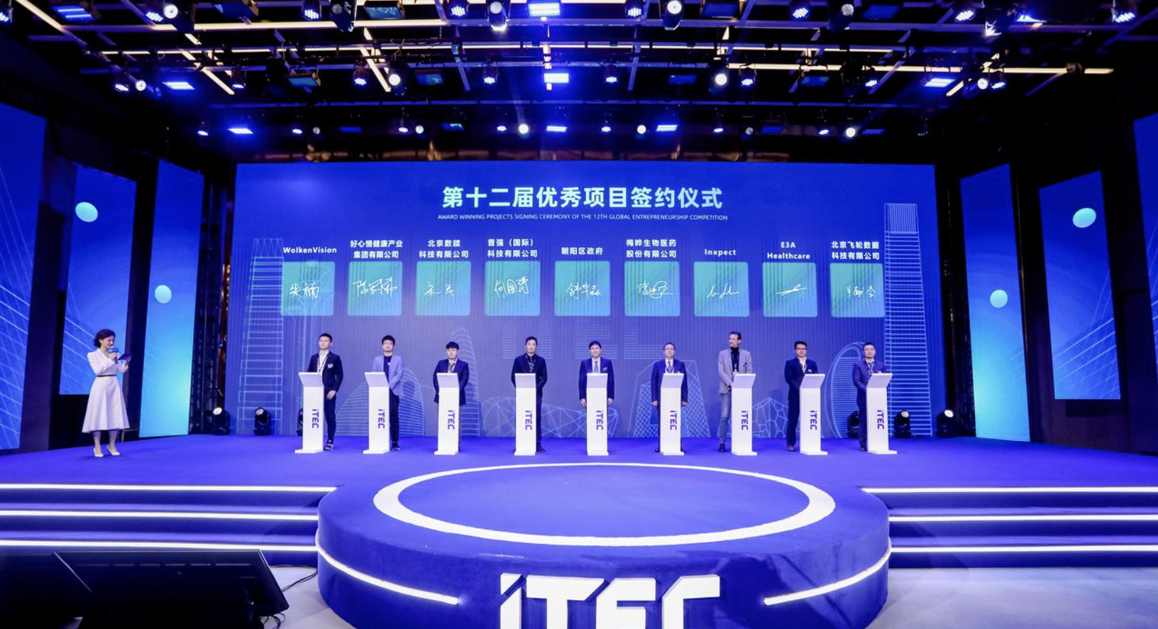
WolkenVision Wins the Excellence Award at the 12th Chaoyang International Talent Entrepreneurship Conference Innovation Summit, Leading the Digital Future with 3D AI Technology
2025-02-24
View Details
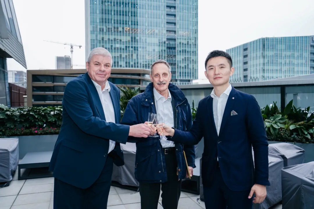
WolkenVision AG and Amberg Group, the world's largest rail scanning hardware service provider, establish long-term strategic partnership
2024-03-18
View Details
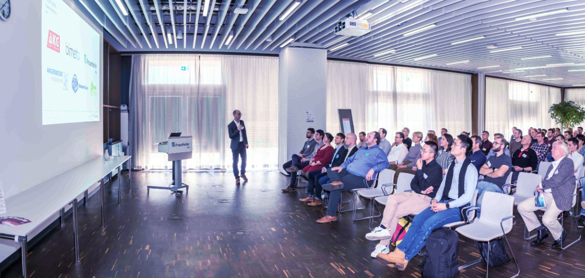
WolkenVision at MoLaS European Large Scale 3D Scanning Exhibition in Germany, exploring the new boundaries of 3D technology
2024-12-02
View Details
· Online documentation
· Community forum
· Standardized support SLA
· Limited email support
· Remote installation help
· Basic troubleshooting
· Limited remote assistance
· Per-seat usage
· Export quota limit
· Usage-based billing
· Enterprise data management
· Custom AI analysis engines
· Joint development support
· E-mail support
· Live chat support
· Dedicated manager (1st month)
· Limited on-site guidance
· All Basic plan features
· SLA-backed operations
· Enterprise-grade stability & modeling
· Monthly or annual plans
· Fixed seats & export quotas
· Flexible feature bundling
· Advanced/custom segmentation
· Expanded segmentation
· Faster processing speed
· Advanced Scan2BIM reverse modeling
· 1-on-1 advisor with 24/7 support
· On-site assistance & training
· Custom workshops & pilot projects
· End-to-end delivery support
· All Professional plan features
· SLA-backed operations
· Enterprise-grade computing & stability
· Annual subscription only
· Fixed seats & unlimited exports
· Full product suite access
· Large-scale custom deployment
· Expanded segmentation
· Faster processing speed
· Advanced Scan2BIM reverse modeling
Contact Us
Share your vision with us
— we’ll bring the technology to make it real.

Thank you for reaching out!
Our team will be in touch shortly.
Tell us about your project so we can tailor the best solution for you.

with high-precision engineering-usable digital models
Industries & Solutions
© 2025 WolkenVision AG.